Mont Blanc Circuit Hike - 10-Day Self-Guided
Explore the Mont Blanc Circuit a 10-Day Self-Guided Trek from Chamonix
Book in advance and secure your spot with Howlanders!
Briefing
Ready for the Adventure?
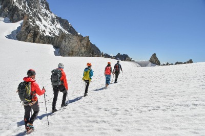
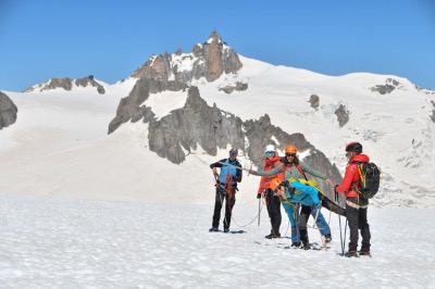
Take on the Mont Blanc Circuit Hike – a 10-day self-guided trek through 3 countries: France, Italy, and Switzerland. Experience breathtaking views of snow-capped peaks, alpine villages, and stunning landscapes as you circle the Mont Blanc massif, starting from Chamonix, France.
You’ll spend your nights in cozy accommodations across all three countries, meeting fellow hikers and enjoying local cuisine.
We handle all the logistics, so you can focus on the adventure. Your tour includes all accommodations, half board (breakfast and dinner), self-guided materials, and a pre-tour briefing. Plus, our team in Chamonix will be there to assist you along the way for a worry-free experience.
Book with us and get ready for the adventure of a lifetime!
Tour details
Included
- 9 nights lodging
- Half-board meals (9 breakfasts and 6 dinners)
- Bellevue cable car and elevator
- Itinerary details (roadbook, GPS tracks, maps)
- Emergency assistance from Chamonix
Not included
- Transfers during the tour
- Meals and snacks during the route
- Rescue and repatriation insurance (mandatory)
- Dinners days 4,5,9 and 10
- Luggage transport (maximum 33 lb (15 kg), available as an extra)
Important information
How to Book the 10-Day Tour du Mont Blanc with Howlanders
Booking your 10-day Tour du Mont Blanc adventure with Howlanders is simple. Just follow these steps:
1. Select your dates and travelers:
Choose your desired dates on the calendar and add the number of travelers. Then, fill in the passenger details and pay a 20% deposit to start the booking process.
2. Limited availability and manual verification:
This tour includes 9 nights of accommodation. Due to high demand and limited availability, all bookings are manually verified. As a result, we cannot provide instant confirmation on our website.
3. Reservation request processing:
Once we receive your deposit payment, we’ll process your booking request. If we confirm availability for the 9 nights of accommodation on your chosen dates, we’ll notify you to proceed with the remaining 80% payment.
4. Final payment and confirmation:
The remaining 80% balance must be paid no later than 50 days before the tour start date. Once we receive the full payment, we’ll send you the final confirmation, including all the details you need to fully enjoy your 10-day Tour du Mont Blanc.
Not recommended for children under 12 due to the difficulty of the hike.
Cancellation policy
Flexible cancellation policy
- If you cancel at least 45 days before the start of the tour, you will receive an 80% refund of the amount paid.
- If you cancel between 44 and 15 days before the start of the tour, you will receive a 20% refund of the total cost.
After this time or in case of a no-show, no refund will be provided.
*The same policies apply to reservation modifications.
Tour itinerary
Tour preparation meeting
Chamonix
The day before the start of the tour you will have a meeting with your trip coordinator to prepare all the details of your route. The coordinator will provide you with all the necessary material for this self-guided tour and will make sure that everything is working properly. In addition, he/she will answer any questions you may have, give you practical advice to help you enjoy the route and will be your contact person in case you have any incident along the way.

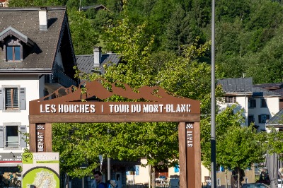
DAY 1 Chamonix - Brévent - Les Houches
Approximate distance: 12km (7.45 miles)
Elevation gain: 545m. (1,788feet)
Elevation loss: 1560m. (5,118 feet)
Lodging: Les Houches.
Meals: Dinner
Start of the Tour of Mont Blanc in Chamonix
Welcome to the starting point of your incredible excursion! You will take the Planpraz cable car (one-way ticket included) and hike to the Brevent pass and the summit of Brevent (2525m - 8,284 feet). Here you will enjoy incredible views of Mont Blanc and its glaciers. You will then descend to the Bellachat refuge, where you can rest before descending to Les Houches. Overnight in Les Houches.

DAY 2 Les Houches - Col de Tricot - Les Contamines-Montjoie
Approximate distance: 13km (8.07 miles)
Elevation gain: 700m. (2,297 feet)
Elevation loss: 1325m. (4,347 feet)
Lodging: Les Contamines.
Meals: Dinner and breakfast included.
Hike from Bellevue across a suspension bridge
You will start the day by taking an elevator from Les Houches to Bellevue (one-way ticket included). Here you will start hiking on a beautiful crossing that will take you under the Bionnassay glacier from a Nepalese suspension bridge.
You will then ascend through alpine pastures to the Col du Tricot (2120 m - 6,955 feet). Here you can rest and take in the panoramic view of the Contamines-Montjoied valley before descending a steep path through the rustic houses of Miage (1559 m - 5,115 feet).
Finally, you will go around Mont Truc (1811 m - 5,942 feet) to reach the village of Les Contamines-Montjoie, where you will spend the night.

DAY 3 Les Contamines-Montjoie - Col du Bonhomme - Les Chapieux - Bourg Saint Maurice
Approximate distance: 15km (9.32 miles)
Elevation gain: 1295m. (4,249 feet)
Elevation loss: 950m. (3,117 feet)
Lodging: Bourg Saint Maurice
Meals: Dinner and breakfast included.
Stage through the massifs and the village of Chapieux
From your accommodation, you will reach Notre-Dame-de-la-Gorge (1210 m). Then, it is a progressive hike to the Bonhomme pass (2329 m), between Mont-Blanc and the Beaufortain massif.
You will continue ascending until you reach the Croix-du-Bonhomme pass (2433 m), from where you can see the beautiful landscape of Mont-Pourri (3779 m).
You will then descend through an alpine pasture that will lead you to the village of Chapieux. From Chapieux, you will take a bus (not included) to Bourg Saint Maurice, where you will spend the night, and get some well-deserved rest!

DAY 4 Bourg Saint Maurice - Ville des Glaciers - Col de la Seigne - Val Veny - Courmayeur
Approximate distance: 15km (9.32 miles)
Elevation gain: 755m. (2,477 feet)
Elevation loss: 880m. (2,887 feet)
Lodging: Courmayeur
Meals: breakfast included
Arrival at the Italian border
To reach the starting point you will take a bus (not included) to the Ville des Glaciers (1800 m - 5,906 feet) and start walking from there. You will then ascend through an alpine pasture to the pass of La Seigne (2516 m - 8,255 feet).
You have reached the Italian border. You will enjoy a breathtaking viewpoint with views of legendary peaks such as Mont-Blanc
of Courmayeur, Noire de Peuterey and Grandes Jorasses.
You will then descend on foot to the Val Veny, at the end of the Miage glacier. From there, you will take the local bus to Courmayeur (1226 m - 4,022 feet), the capital of the Italian Alps, where you can rest at your accommodation.

DAY 5 Courmayeur - Refuge Bonatti- Courmayeur
Approximate distance: 12km (7.46 miles)
Elevation gain: 1080m. (3,543 feet)
Elevation loss: 300m. (984 feet)
Lodging: Courmayeur
Meals: breakfast included
Saxe Mountain
Today you will discover the beauty of Mont de la Saxe. From Courmayeur, head to the Bonatti refuge for a spectacular hike on Mont Saxe, which offers magnificent views of the entire southern slope of the Mont Blanc chain with mythical peaks and impressive glaciers on the horizon until you reach the refuge of the famous Italian mountaineer Walter Bonatti (2022 m - 6,634 feet). You will return to Courmayeur for the night (possibility to return to Courmayeur by bus or on foot).

DAY 6 Val Ferret - Grand Col Ferret - La Fouly
Approximate distance: 15km (9.32 miles)
Elevation gain: 825m. (2,707 feet)
Elevation loss: 990m. (3,248 feet)
Lodging: La Fouly
Meals: dinner and breakfast included.
Arrival at the Swiss border
From Courmayeur, you will take the bus to Arnouva, where you will start your excursion to Val Ferret and climb up to the Elena refuge (2061 m - 6,762 feet) in front of Mont Dolent (3820 m - 12,533 feet). Afterwards, you will continue to the Grand Col Ferret pass (2537 m - 8,323 feet) to enter Switzerland. Enjoy a last espresso before descending to the village of La Fouly where your dinner and rest await.

DAY 7 La Fouly - Val Ferret - Champex
Approximate distance: 16km (9.94 miles)
Elevation gain: 580m. (1,903 feet)
Elevation loss: 740m. (2,428 feet)
Lodging: Champex
Meals: dinner and breakfast included.
Lake Champex
You will start the day from La Fouly with an easy walk that will take you to the village of Praz le Fort (1151 m - 3,776 feet). The trail follows the Ferret river to the village of Issert. Then you will climb up to the beautiful Champex lake (1477 m - 4,846 feet). If you want, you can even take a dip in its crystal clear waters.

DAY 8 Champex - Bovine alpine pastures - Trient
Approximate distance: 14km (8.70 miles)
Elevation gain: 845m. (2,772 feet)
Elevation loss: 1007m. (3,304 feet)
Lodging: Trient
Meals: dinner and breakfast included.
Route along the cattle track
Leaving Champex, you will continue to enjoy this picturesque area starting with an hour and a half of easy hiking along the "via pecuaria" (cattle track) that ranchers once used to guide their cattle through the mountains.
Continuing through the mountainous terrain, you will enjoy views of the Dents du Midi and climb through the forest to viewpoints overlooking the beautiful Rhone Valley and the beautiful Rhone valley and the town of Martigny.
Finally, you will descend to the Col de la Forclaz and arrive at your accommodation in Trient.

DAY 9 Trient - Col de la Balme - Argentière
Approximate distance: 14km (8.70 miles)
Elevation gain: 1140m. (3,740 feet)
Elevation loss: 1020m. (3,346 feet)
Lodging: Argentière or Trélechamps.
Meals: breakfast included.
Return to France
Your last day of hiking will take you back to France. From Trient, you will hike to the Col de Balme, the border between Switzerland and France. Enjoy the incredible views of Mont Blanc before an easy descent to Montroc. From there, walk to your accommodation in Trélechamps or Argentière.

DAY 10 Trélechamp - Chamonix
Approximate distance: 16km (9.94 miles)
Elevation gain: 1050m. (3,445 feet)
Elevation loss: 1405m. (4,610 feet)
End of the tour in Chamonix
On the last day, a real gift of nature awaits you. This stage in the Aiguilles-Rouges massif faces the summit of Mont Blanc and offers a spectacular view of glaciers and peaks. From the Montets pass (1461 m - 4,793 feet), you follow a trail to the Chéserys lake, which reflects the most famous mountain in the Alps! You will continue to the beautiful Lac Blanc (2352 m - 7,717 feet). You will then descend to La Flégère (1877 m - 6,158 feet) to reach Les Praz de Chamonix mountain.
Congratulations! You have reached the end of the tour.

What to bring to Mont Blanc Circuit Hike - 10-Day Self-Guided tour
During the summer season you can enjoy good weather, but this can change quickly, so be prepared for rain and large temperature differences throughout the day. We recommend the 3-layer system, as well as appropriate footwear.
- Medium sized trekking backpack (40 liters approx.)
- Rain cover for the backpack
- Identity card / passport
- Documentation of your travel insurance
- Documentation given to you before the tour (maps, accommodation reservations, etc.)
- Phone and charger (and adapter for plugs)
- Liner for sleeping bag (mandatory)
- Hiking pants: thin or short.
- Long hiking pants for extra warmth.
- First layer: thermal T-shirt and short-sleeved T-shirt.
- Middle layer: polar fleece or similar.
- Outer layer: waterproof jacket
- Hiking shoes (if possible waterproof boots)
- Mountain socks
- Resting shoes
- Sandals (for showers)
- Personal hygiene products
- Soap in case you need to wash clothes
- Flashlight and battery
- Cap or hat
- Sunscreen
- Sunglasses
- Refillable water bottle
- Travel knife and fork
- Walking sticks
- Credit card and cash (EUR and CHF)
- Garbage bag
- Ear plugs
*If you hire the luggage transfer service you will need, in addition to the backpack to be transported between accommodations, a small backpack to carry with you during the day.
Where does the tour Mont Blanc Circuit Hike - 10-Day Self-Guided start
- By plane: the nearest airports are Geneva, Lyon and Milan, and are less than two hours from Chamonix. It is best to fly to Geneva airport.
- By train: Chamonix is served by trains from Paris, Lyon, Annecy, Bellegarde, Geneva and Martigny.
- By road: Chamonix is well connected by road, especially thanks to the Mont Blanc tunnel, which allows direct access from Italy.
Questions & Answers
How far in advance should I book?
We recommend booking as far in advance as possible. Many travelers book a year in advance, as the Tour du Mont Blanc is a popular route with limited availability of accommodations.
How do I take the transports between stages?
The distances covered during the transfers are short, that is why local buses are used, you will be explained how to take them and the schedules during the meeting prior to the start of the tour. If you take the tour in June or September, some buses will not be available and you will have to take a cab.
Where will I stay? What are the accommodations like?
Due to low availability we cannot guarantee the exact accommodation where you will stay, we will do so when confirming your reservation.
The most booked option combines shared rooms in mountain refuges with private rooms in rural lodges. The tour can be customized and the type of accommodation can be adapted according to your preferences.
Is it a very demanding route and do I need to be in good shape?
The route has no special technical difficulty, but it is important to be fit and used to mountain routes, as fatigue accumulates over the days. In the description of each day we indicate the distance covered so that you can evaluate the difficulty yourself.
How does the baggage transport service work?
Luggage transport is a service offered as an extra. You will deliver your luggage to your accommodation and you will find it when you arrive at the next accommodation. Please note that this service only transports one soft bag per person (no hard suitcases) with a maximum weight of 15 kg. If you select this extra you will have to stay in a hotel in Chamonix the night before and at the end of the tour, as they will need to be able to access your luggage throughout the day.
How can I orient myself during the self-guided tour?
The day before the tour starts you will meet with your tour organizer who will give you the maps in paper and PDF with the marked routes. In addition, you will download the maps and the route to your phone's GPS so that you can follow it very easily.
Are there any risks when walking in areas where there is snow?
The tour begins in mid-June when there may still be trails with snowy areas that pose no risk to the experience.
Of course, snow can be slippery. But sliding is not a problem as long as the slope allows it; no rocks at the bottom, soft snow, speed control.... So you don't have to worry because it is totally normal and you will walk on very well marked trails with the help of the roadbook and GPX tracks.
What kind of food is offered for breakfast and dinner?
We don’t have exact information about the dinners, but they usually include simple options with vegetables, carbohydrates, and proteins. For breakfast, there are typically sweet options like bread with jam, fruits, and sometimes yogurt, as well as savory options like eggs.
If you have allergies, please contact us so we can take them into account.
For lunch, you can request a picnic to be prepared at your accommodation when you check in (approximately 12-15€) or eat at some of the huts along the way.
When does the pre-briefing take place in Chamonix?
The in-person briefing is held the day before the tour begins. It can take place in the morning from 9:30 am to 4:30 pm and lasts about 1 hour.
The briefing cannot be done right before the hike starts, as you may need to buy equipment or snacks, and we want to avoid you starting the first hiking day in a rush or with stress.
What is the roadbook?
The roadbook is a detailed document that explains your itinerary day by day. It includes distances, elevation changes, and the detailed route for each day, along with a GPX track in the Gaïa GPS app.
It also contains information about your accommodations, check-in/check-out times, breakfasts and dinners, addresses, and transport details.
You will receive a first draft 30 days before your trip, and the final version a few days before departure.
Is it necessary to obtain a permit to do the Mont Blanc Tour?
No, you do not need any permits to do the Mont Blanc Tour.
Are bathrooms available at all accommodations?
Yes, all accommodations have bathrooms. In the shared dormitory option, the facilities are shared with other hikers. If you choose private rooms in hotels, you will have a private bathroom.
Where can I store my luggage in Chamonix while I do the hike?
You can ask at your hotel if they can store it while you're on the hike, as most hotels allow this. Another option is Cham Lockers, an automated locker service near the Chamonix train station. You can rent them by the hour, day, or long-term.
Should I bring water and food during the hike?
It is recommended to bring 1.5 liters of water (2 liters on hot days). You can refill your bottle or camelback each morning at the accommodations and at some mountain huts. Some hikers bring purification tablets to use water from streams.
It’s also a good idea to bring snacks, which you can buy in Chamonix, Contamines, Bourg Saint Maurice, and Courmayeur. Some huts also sell snacks, but with limited options.
Can I do the Mont Blanc trek with my dog?
Yes, it’s possible, but the itinerary will need to be adjusted, as the accommodation planned for some stages is in dormitories, and these do not accept dogs. If you plan to do the trek with your dog, contact us and we will provide you with an adapted itinerary.
Mont Blanc Circuit Hike - 10-Day Self-Guided tour reviews with Howlanders
Other tours that might interest you
- (3 reviews)Chamonix, France6 daysSelf-guided
Other travelers also booked
- (1 reviews)Chamonix, France1 dayEnglish and FrenchFree cancellation!
- (2 reviews)Chamonix, France1 dayFrench and EnglishFree cancellation!
- (1 reviews)Chamonix, France1 dayEnglish and FrenchFree cancellation!
- (2 reviews)Camino de Santiago, Spain7 daysSelf-guidedFree cancellation!